Tutorial: Make a 3D Globe in Illustrator
Adobe Illustrator and Gerhardus Mercator |
||||||||||||||||||
 |
||||||||||||||||||
|
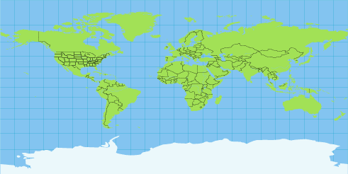
The Mercator World, scanned from a 1953 encyclopedia and traced in Adobe Illustrator. Click to download a PDF of the map. It's a vector file and can be opened in Illustrator. |
||||||||||||||||||
|
In the 16th century, most seamen knew the earth was a globe. Navigating at sea was fairly easy if the ships stayed within sight of land, or when sailing across a relatively small and familiar body of water like the Mediterranean Sea. But when sailors ventured out into the ocean, navigation from point to point became difficult. Existing maps showed land forms and relative distances, but they were extremely inaccurate because of their failure to consider the curvature of the earth’s surface. In 1569, cartographer Gerhardus Mercator published a map of the world that for the first time attempted to deal with this problem. His solution was to draw the earth’s lines of longitude, which describe circles around the globe that intersect at the poles, as vertical and parallel. This offered an advantage to marine navigators in that true north was always straight up. The disadvantage to Mercator’s projection was that horizontal distances were exaggerated; as one approached the poles, land masses appear increasingly distorted. The Mercator projection was a popular world map from the time it was first published until fairly recently. It has now been replaced by more accurate projections, and it is difficult to find one in print today. While Mercator took the imaginary curved lines that run north and south along the earth’s surface and represented them as vertical parallel lines on paper, the 3D Revolve Effect in Adobe Illustrator uses its artwork mapping feature to do the inverse. It permits a rectangular Mercator projection map of the earth to be wrapped around a globe to yield an accurate 3D globe. |
||||||||||||||||||
 |
||||||||||||||||||
|
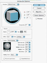
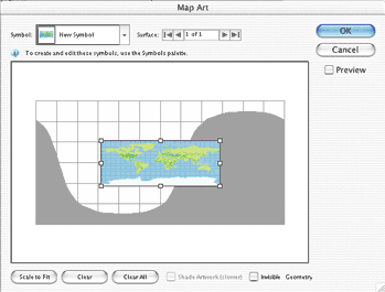
Here's a step-by-step guide to creating your own 3D globe of the earth, using the traced Mercator map and Adobe Illustrator. Step 1. Download the PDF of the map (above), drag it onto the Illustrator application icon, and allow it to open. Select and copy the Mercator projection map, paste it into a new AI document, and leave it selected. In the Symbols panel, click on the New Symbol button. The map becomes a symbol, and you can now delete the map. Step 2. Get the Ellipse tool. Hold down the Shift key, and drag out a circle. For best results, give it a light fill and no stroke. Direct-select the left-most anchor of the circle and delete it, leaving a half-circle. Step 3. With the half-circle selected, go to the Effect menu and choose 3D > Revolve... In the 3D Revolve Options dialog, click on the Preview button. By default, a selection is revolved around its left-hand axis 360 degrees. The preview shows that the half-circle has become a globe. Step 4. Click the Map Art button. The Map Art window appears, showing a grid with the globe’s single surface flattened out in a Mercator projection. The curved shadow area represents the globe’s far side. Click on the Symbols list, scroll down and choose the new Symbol you created in Step 1. It appears on the grid. Click the Scale to Fit button to fit the map to the entire surface. Click OK. |
||||||||||||||||||
3D Revolve Options from Adobe Illustrator. |
||||||||||||||||||
 |
||||||||||||||||||
 |
||||||||||||||||||
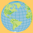
Step 2 |
||||||||||||||||||
 |
||||||||||||||||||
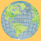
Step 3 |
||||||||||||||||||
 |
||||||||||||||||||
|
Step 5. The flat map has been wrapped around the globe, and appears in the preview. You may now drag the edges of the cube in the 3D Revolve Options window to re-orient your view of the globe from any angle. Click the OK button and save. Step 6. As long as the globe remains in its current state as an Effect applied to a half-circle shape, its 3D attributes are editable by clicking the Effect in the Appearance panel. You may flatten the globe’s appearance in the Object menu to convert it to regular 2D art that can be edited the same as any other art in Illustrator. The far side of the globe is grouped separately, so you can creatively add gradients, transparency and drop shadows, as you wish. |
||||||||||||||||||
Step 4 |
||||||||||||||||||
 |
||||||||||||||||||
 |
||||||||||||||||||
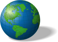
Step 5 |
||||||||||||||||||
 |
||||||||||||||||||
For some additional fun, go to my favorite web site, Astronomy Picture of the Day (APOD) and download the high-resolution versions of these images: http://antwrp.gsfc.nasa.gov/apod/ap020305.html Place in Illustrator, embed, and make them Symbols, and then map them onto a 3D globe. I'm still looking for Mercator projection images of the Moon, Mars and other members of the Solar System. Have fun! |
||||||||||||||||||